
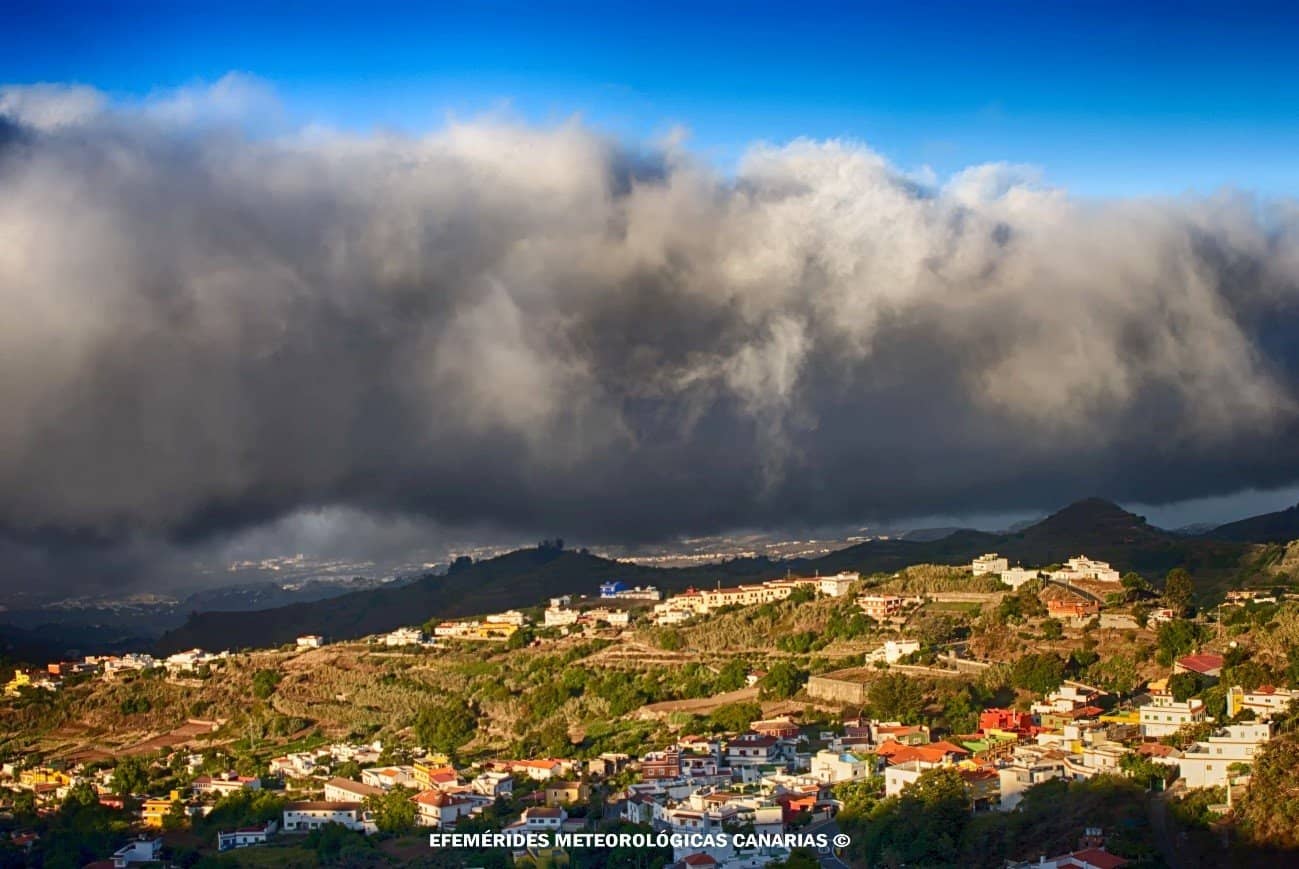
Donkey belly: clouds and mountains
The north of many Canary Islands awakens under a gray ceiling that seems to descend so much that it feels almost touchable. This dull sky, with its muted brightness and unexpected coolness in the middle of summer, has a name recognized throughout the archipelago: donkey belly. The image is accurate. The base of the cloud, smooth and leaden, resembles the belly of the animal. Above, however, starting from a certain altitude, the sun shines with an almost insulting clarity, and the sea of clouds stretches like another ocean, white and static. This scene, seemingly taken from a novel, envelops the observer in an atmosphere befitting the Canarian essence, inviting contemplation of the unique beauty of living in the Canary Islands.
There is science, landscape, and culture in that mantle. There are also daily rhythms, seasons, and an intimate relationship between the winds and the volcanic relief that turns the Canary Islands into an open-air laboratory.
What exactly is the belly and why does it look like that?
It is a layer of low stratocumulus clouds typically situated between 500 and 1,500 meters, adhering to the windward slopes, mainly in the northern and northeastern aspects. It is not fog in the urban sense, nor storm clouds. It is a stagnation cloud, continuously fed by the trade winds, moving leisurely and maintaining a very uniform base. Hence its visual texture and its graphic nickname. Additionally, the term "donkey belly" evokes the image of a robust animal, reinforcing the feeling of connection with Canarian identity at every dawn.
The popular name has local variations, such as donkey belly, and is so rooted that in Las Palmas de Gran Canaria it is part of the daily conversation in summer. What seems like an endless overcast from the coast is a spectacle from the peaks: a cotton-like plain that fills the valleys and ends at an invisible “ceiling.”
That ceiling exists. It is the thermal inversion, a layer of warmer air situated approximately between 1,000 and 1,500 meters. When the humid air mass rises up the slope, it cools, reaches its dew point, and condenses. Upon reaching the inversion, the ascent is halted, the cloud flattens, and spreads horizontally.
The hidden engine: trade winds and anticyclone
The mechanics are elegant. In spring and summer, the Azores anticyclone dominates the northeastern Atlantic. Its circulation favors trade winds from the north and northeast, cool and laden with moisture after crossing relatively cold waters. These winds are constant and persistent, the true engine of the belly. Watch the effects of these phenomena live through webcams set up at strategic points, an ideal resource for those wishing to appreciate the behavior of the donkey belly.
- Mild, humid, and stable marine air in the lower layers.
- Subsidence at height that reinforces the thermal inversion.
- Abrupt relief that forces the humid mass to ascend.
The result: a recipe for stability above and continuous nourishment below. The low cloud cover regenerates without pause as long as the trade winds keep blowing and the anticyclone maintains its framework. That’s why, in July and August, the north of Gran Canaria or Tenerife accumulates so many gray days, and that’s why the south, sheltered from the wind, boasts almost daily sunshine.
The mountain commands: clouds that climb, clouds that hesitate
The islands with the highest altitude dictate the rhythm of the clouds. As the humid air meets very steep slopes, its ascent accelerates and condensation intensifies. Hence, the La Orotava Valley, the midlands of Gran Canaria or the forests of La Palma know the persistent fogs so well. When the inversion is low, the stratocumulus literally hangs from the orography, as if embracing the mountain.
Sometimes, even, the phenomenon bends to local whims: mountain waves forming lenticular clouds over the Teide, white crowns that look like well-held hats, or cascades of clouds spilling over a ridge and dissolving as they fall down the southern slope. The drama in the sky, almost like a visual novel, invites the viewer to live in the Canaries with a mix of wonder and envy at such contrasting landscapes.
From above, the spectacle is called sea of clouds. The term is not merely poetic. When viewed from peaks like the Roque de los Muchachos, the white horizon is so homogeneous that it resembles a calm sea. At the same time, just a few kilometers away, the northern coast experiences a midday with filtered light, moderate temperature, and a benevolent humidity for the vegetation.
Daily and seasonal rhythms
The belly has a clock. On days with well-established trade winds, the layer of stratocumulus usually forms vigorously during dawn and morning, when the thermal contrast favors condensation. As the day progresses, it may open up patches of clear skies or rise a little without disappearing. At dusk, the system reorganizes and the layer easily reconstitutes. Like a novel, the day unfolds with the same care as a gardener organizing their garden, where every detail is essential for balance.
In the calendar, its frequency increases with the power of the anticyclone: late spring and summer concentrate the longest episodes. Winter brings more fronts, the inversion weakens or descends, and clearer days appear in the north.
Very tangible effects: mild climate and water that arrives from the air
The cloud is not just a postcard. It acts as a natural umbrella that reduces direct radiation, lowers the maximum temperature, and cushions the daily thermal amplitude. There is a notable thermal benefit in cities like Las Palmas de Gran Canaria during the warmer months. Every plant in the vegetation, as vital as the most symbolic in a garden, benefits from this regulation, providing relief to the local agriculture.
And there is a key phenomenon for ecosystems: horizontal rain. The suspended moisture deposits on the leaves and branches of the laurisilva and pine forests of the midlands. Tiny droplets coalesce, drip, and nourish the soil. This water contribution does not appear in standard rain gauges as a classic downpour, but it sustains cool soils, ravines with permanent vegetation, and a persistent greenery on the slopes exposed to the trade winds.
In agricultural terms, it means:
- Less water stress in north-facing midland crops.
- Reduced direct sunlight and evaporation.
- Microclimates suitable for fruit trees and gardens that would benefit from excess sun in the south.
For tourism, the belly is an asset. Those seeking beach and sun find refuge in the south. Those longing for trails, humid forests, and mild temperatures head north. In a single day, with just a few kilometers of difference, the range of sensations is extraordinary.
Where the belly of the donkey shows more character
- Gran Canaria: north and northeast from Arucas to Agaete, midlands of Teror, Moya, and Valleseco. Roque Nublo often peeks above the layer when the inversion is low.
- Tenerife: La Orotava Valley, Anaga and Teno. Teide and the Izaña Observatory often remain above, with a vast sea of clouds.
- La Palma: ridge of Cumbre Nueva and surroundings of Roque de los Muchachos. The flow of clouds climbing from the northwest is proverbial.
- La Gomera and El Hierro: northern massifs with persistent mists, humid forests fed by horizontal rain.
These areas, which seem taken from the page of a novel, reflect the authentic Canary lifestyle and are part of the Canarian essence that enchants those who decide to live in the Canaries. Lookouts and forest paths bordering 1,200 meters are often perfect balconies. If the inversion is particularly low, 800 to 1,000 meters are enough to break through the mists. If it rises, the layer can reach 1,400 or 1,500 meters and cover even some passes.
Signs to anticipate it without the need for models
The belly can be "read" with a few clues:
- Dominant wind from the north or northeast with moderate to strong intensity.
- High relative humidity at the coast and midlands during the night and morning.
- Temperate sea temperature and general stability, with no fronts in sight.
- Radiosonde data or reports placing the inversion near 1,000 to 1,300 meters.
- On satellite, band of low, compact stratocumulus with a granular texture.
If, at dawn, the north wakes up with grayish strata and mist in the midlands, there are many chances that the day will remain under the mantle.
Microclimates by altitude: what usually occurs at each level
Altitude organizes the mosaic. This guidance table describes typical conditions on days of well-established belly, with prevailing trade winds.
| Altitude level | North (windward) on a belly day | South (leeward) on a belly day |
|---|---|---|
| at 300 m | Persistent low cloudiness, diffuse light, mild temperature, light mist | Few clouds, more sunlight, moderate breezes |
| 300 to 800 m | Layer of stratocumulus brushing the slopes, reduced visibility in sections, occasional drizzle | Sunny or with weak local cloud development |
| 800 to 1,300 m | Belly's heart: frequent fog, horizontal drizzle, humid forests | Transition to clear skies and warm feeling |
| 1,300 to 1,800 m | Variable upper edge; if the inversion is low, the sky usually opens up here | High probability of being above the layer |
| > 1,800 m | Sun with a sea of clouds at foot level, reinforced wind on ridges | Sun and greater thermal amplitude, lenticular clouds if there are waves |
It's not an unchangeable rule, but it helps plan routes and understand why the same day delivers wet coffee coasters in Orotava and sunscreen in Adeje.
The 'engineering' of the relief: why the peaks shape the sky so much
The physics behind those photogenic shapes can be summarized in the simplest mental equation: humid air plus slope equals condensation. The mountain acts as a ramp and barrier. It forces ascent, cools by expansion, and condenses. If the inversion is strong, the ascent gets blocked, and the cloud extends. If the flow is intense and perpendicular to a ridge, waves appear in the current, with maximum and minimum pressure favoring lenticular clouds. Teide often receives that crown. On a more local scale, passes and cols channel the wind, creating waterfalls of clouds that 'pour' to the other side and evaporate in seconds upon entering drier air.
The leeward side, to the south, heats and dries by adiabatic descent, an effect comparable to Föhn. That is one of the reasons for the marked contrasts between north and south: green and humid landscapes versus golden slopes and clear skies.
Science and culture: from saying to measurement
The phrase 'today there is belly' is used to decide whether to go down to the southern beach or to climb to the summit to see the sea of clouds. But it has also been the subject of careful measurements: mountain stations record water contributions from fog collectors, radiosonde series show the height of the inversion, and seasonal averages confirm the high recurrence in summer.
In day-to-day life, the cloud conditions:
- Energy consumption, thanks to homes and businesses requiring less climate control.
- Design of school and tourist routes on roads with reduced visibility in midlands.
- Agricultural calendars that take advantage of milder temperatures and constant humidity.
The belly has shaped even urban character. Many facades in the north display bright colors that shine more under diffused light, and pedestrians get used to a clarity without hard shadows that makes midday more pleasant.
How to enjoy and study it on the ground
Those wishing to photograph the sea of clouds appreciate waking up early. The first hours reveal delicate transitions between mist, clear skies, and strata. Sunsets, with the sun lowering and the layer stabilized, gift backlighting that makes peaks and craters float like islands within the island.
Three practical ideas:
- Choose balconies between 1,200 and 1,500 meters if the report places the average inversion. If low inversion is expected, 900 meters may be enough to get above the layer.
- Look for perpendicular alignments to the trade winds to capture lenticulars or 'hats' on isolated summits.
- Consider a wide-angle objective to cover the white plain and a telephoto lens to compress layers and silhouettes.
For those who prefer measuring, a cheap hygrometer and a notebook already allow for exploring the variation of relative humidity with altitude in a single day, ascending from the northern coast towards the mid-elevations. Noting gusts, wind direction, and temperature provides a little treasure of data that fits with the physical explanation.
Comparisons that clarify the picture
There are distant relatives of this Canary cloud. The stratocumulus layer of the eastern Pacific, off California or Chile, works with a similar script: cold waters, stability, and an inversion that crushes the cloud. Madeira and the Azores also know their days of gray skies and cloud seas on summits, although the orography and position change the details. In the Canaries, the abrupt volcanic relief and the proximity to the cold current intensify the pattern and make it very visible on a human scale.
Will the belly change with a different climate?
Projections about the behavior of the subtropical high and the temperature of the Atlantic are very interesting here. If the ocean warms and the stratification changes, one can expect adjustments in the frequency and height of the inversion. Episodes of anomalously warm surface waters have already shown their impact on the formation of stratocumulus in other basins. On the other side of the scale, a more persistent high would reinforce stability and, with it, the belly.
The most likely scenario is greater variability in duration and intensity, with belly-laden summers alternating with more open skies in the north. At the foot of the island, this translates to seasons where the laurisilva receives more or less 'horizontal rain' and, therefore, into visible nuances in soil humidity and plant vigor.
Why are we so drawn to this sky
There is a powerful aesthetic in the belly. From below, the uniform light softens color and enhances textures. From above, the sea of clouds turns mountains into ephemeral archipelagos. And all occurs in predictable, almost pedagogical cycles. This iconic phenomenon reinforces the Canary identity and the intimate connection between land and sky, reminding us of the depth of a novel that is written each day. Those who visit the Canaries may feel that within the same island there are simultaneous seasons. The belly is one of the keys. It allows the north to be humid when the calendar calls for warmth and the south to be pleasant when other places suffer extremes. It keeps the forests hydrated without the need for storms. And it offers, to anyone who climbs a bit, that unforgettable image: a white plain that embraces the mountain and finally lets the radiant sun peek through.