
Discover the viewpoint route in La Gomera
Imagine looking out over an ocean of green ravines, petrified fire rocks, and natural balconies from which, on clear days, the Teide seems to levitate on the horizon. From those balconies, it's clear why this island remained untouched by Rome – a clear example of resistance to Roman domination – and why today it attracts the gaze of hikers, photographers, and curious visitors seeking silence, clear skies, sensory experiences (silence), and vibrant culture amidst nature. And if you can't get close, there's another way to look in: live cameras and webcams that place you, in seconds, in front of the changing light of the Atlantic. Even on the website, cookies are used to improve navigation and provide you with the best experience, in the style of the best sustainable tourism guides in the Canary Islands.
A rough, beautiful island that is difficult to subdue
Classical authors mentioned the Fortunate Islands, but Rome never established itself here. La Gomera, with its concentrated relief and its vertical terrain marked by a notable elevation difference, featured ravines, eucalyptus trees, and peaks that catch clouds, while its rugged coast – with beaches scattered at strategic points – was a poorly profitable target for logistics designed for rivers and plains. There were no metals, there were steep slopes, and the geographical isolation combined with a unique resistance to Roman domination. The native inhabitants, experts in a vertical territory, knew every path and every cave, also offering hiking routes that are unforgettable for their adventure and sensitivity to nature.
There are no solid remains of permanent Roman presence in the archipelago. There are tales, ocean routes, and episodic trade, but no infrastructure suggesting effective occupation. In La Gomera, this history is visible at a glance: it’s enough to look from the rocks or from the Fortress of Chipude to understand that anyone attempting to dominate these gorges would need more than just ambition, but a true circular driving route in La Gomera that links viewpoint excursions, culture, and sustainability / environmental respect.
The viewpoint route: a panoramic ring to savor La Gomera
Proposed circular route by vehicle with stops of 10 to 60 minutes, designed for a long day or, better yet, two leisurely days, on a panoramic route in La Gomera full of nature and adventure. It can be completed in a clockwise or counterclockwise direction. Here it is suggested to start in the capital and combine roads GM-1 and GM-2 with brief detours.
- Approximate mileage: 140 km
- Net driving time: 4 to 5 hours – considering constant curves, elevation changes, and spectacular vertical terrain.
- Recommended stops: 10 to 12 viewpoints, including the iconic viewpoint of Espíritu Santo (appearing here for the first time) and another viewpoint of Espíritu Santo later in the route.
- Driving difficulty: medium, with continuous curves and slopes that challenge the driver, ideal for adventure and photography lovers in La Gomera.
A small warning: the best moments of light are very different between north and south. If you like photography in La Gomera, spread dawn and sunset across opposite ends of the island.
San Sebastián and Puntallana: gateway and view to the sea
The capital is a historic port where tradition meets modern transport: ferries and guaguas (buses) that bring life in and out. Shortly after leaving, the detour to Puntallana gifts you with an elevated viewpoint next to the hermitage of the patron saint. Clear dawn, foam in the breakwaters, and sometimes, the shadow of Teide anchored to the northeast.
- Suggestion: a brief walk along the ridge and a visit to the hermitage.
- Best time: early hours of the day, when the air is clearer and the changing weather begins to set the rhythm of the day.
Los Roques and Tajaqué: cathedrals of phonolite and fog forest
Via GM-2, you ascend to the heart. The Los Roques viewpoint confronts visitors with volcanic monoliths that have emerged, polished by millions of years. The most iconic, Roque de Agando, looks like a mast stuck in the sky, and its basalt columns blend into an almost mystical landscape. Further along, Tajaqué offers walkways and a window into the laurisilva, that humid forest that captures horizontal rain and gives drink to the island.
- Suggestion: a light jacket even in summer, the altitude cools.
- Best time: midday with an active sea of clouds or clear afternoons after the trade winds.
- Extra tip: include in your itinerary viewpoints that allow you to experience each moment of this natural miracle.
Chipude and Igualero: the echo of the Silbo from above
The central plateau exudes history. Igualero has a sober viewpoint and a monument to the Silbo Gomero, the language that crosses ravines in the form of long notes. Very close, the Fortress of Chipude rises like a volcanic table laden with archaeology and ancient rituals. From these balconies, one can sense why long-distance communication was both ingenuity and necessity, paving the way for hiking routes that capture the pre-Hispanic history of the Canary Islands.
- Suggestion: if your body calls for a walk, climb to the Fortress via the marked path.
- Best time: early or late hours to avoid heat and glare.
- Remember to also admire the viewpoint of the Espíritu Santo in this area, being one of the privileged points of the route.
Valle Gran Rey and Palmarejo: terraced fields that tell a story
The south and west open the landscape in steps. The Palmarejo viewpoint, designed by César Manrique, overlooks an Valle Gran Rey endless series of terraced fields and homes nestled on stone ledges. The evening light ignites the walls of the terraces and outlines the geometry of centuries of work and local cuisine, highlighting typical dishes and almogrote, palm honey, and goat cheese.
- Suggestion: plan to catch the sunset here. The slanting light is a spectacle.
- Gastronomic stop: don't miss tasting the local cuisine.
- Additionally, explore other areas of the circular driving route in La Gomera if you're looking for a combination of flavor and landscape.
El Santo, Arguamul, and Vallehermoso: the roaring north
The northwest tip is sheer cliff. The viewpoint at El Santo, above Arguamul, offers vertigo and open sea; its panorama is complemented by the vibrant exchange between the ocean and the rock. To the east, Vallehermoso and its green slopes lead to a coastline of lava rock. Not far away is the basalt wall of Los Órganos, a set of basalt columns best appreciated by sea on a boat trip, although understanding its scale from land is also impressive.
- Suggestion: check the wave conditions if you plan to hire a boat.
- Best time: mornings to avoid fog or afternoons with clear skies after the trade winds.
Hermigua, Agulo, and Abrante: a glass balcony overlooking a red and white village
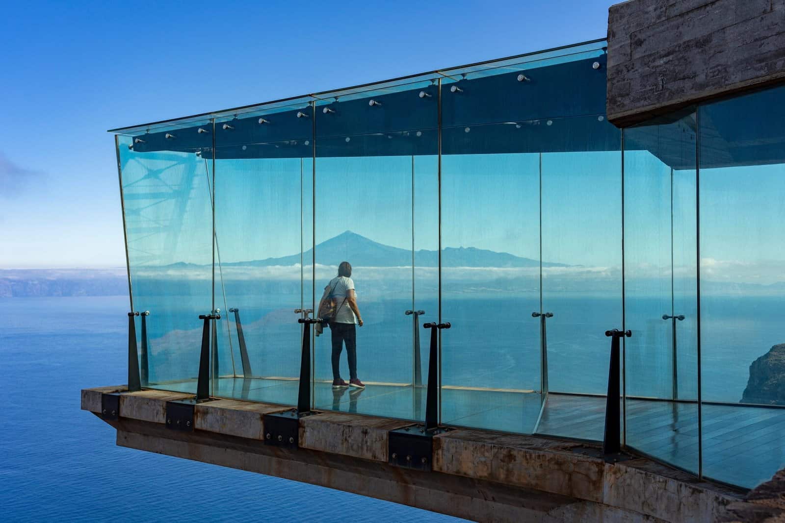
The arch that goes from Hermigua to Agulo offers orchards, banana plantations, and characterful houses. And above, a glass balcony: the Mirador de Abrante. The transparent structure juts out over the void and the village of Agulo, with the mass of Tenerife as a backdrop. In these places, even among eucalyptus and green fields, one experiences a unique feeling, while the color contrast is a delight for the lens and for those enjoying an authentic panoramic route in La Gomera.
- Suggestion: make a reservation if you wish to eat in the viewpoint area or enjoy more local cuisine.
- Best time: midday to afternoon for the contrast of red on the cliffs.
La Laja and the return to the bay: curves that lead to history
Back to the east, the Mirador de La Laja overlooks the basin that descends to the capital. It is a good point to recap the geography: rocks in the center, ravines like spokes, cliffs along the roundabout, and a vertical relief that evokes ancient times. At dusk, the bay of San Sebastián is painted silver and the port bids farewell to another day full of adventures and the essence of La Gomera viewpoints.
- Suggestion: check beforehand if there are works or closures on sections of the descent.
- Best time: evening, with the city lighting up.
Viewpoints with memory: archaeology in sight
Many of these natural balconies are related to places of cultural value, where remnants of pre-Hispanic history of the Canaries can be seen. The Fortaleza de Chipude was a ceremonial space and from its summit, altars and ritual structures can be located. At the peaks of Garajonay, worked stones with symbolic functions appear. The north preserves shell middens and settlements that discreetly peek near paths and cliffs, highlighting the importance of pre-Hispanic history in the Canaries. Observing these places invites sustainable tourism in the Canaries and enjoying environmental respect at every step.
Experience it live: webcams that place you on the balcony
If today you can't take a boat or a car, connect with real-time cameras –even with Canarian webcams– that show weather, light, and atmosphere without filters. Platforms like CanariasLife.com broadcast in high definition from key points in the archipelago, with continuous feed and the possibility of seeing sunrises, fog banks, tides, and the profile of Teide on clear days. This tool is essential for planning viewpoint excursions and hiking routes in La Gomera.
Practical ideas to make the most of:
- Before you go out, check webcams of the summit to decide whether to aim for a sea of clouds or clear skies.
- Alternate between coastal and mountain cameras to anticipate differences in light, considering the changing weather.
- Save as favorites the ones you use in planning, and ensure your offline maps are well set up so you don't get lost.
- If you're traveling with children or seniors, teaching them at home about the places they will visit usually increases motivation and reduces last-minute sea sickness.
In La Gomera, there are cameras installed by local institutions and others integrated into open networks. Watching the bay of San Sebastián, the Alto de Garajonay, or the Valle Gran Rey area live helps in deciding schedules and adjusting photographic expectations for an authentic adventure and photography experience in La Gomera. And if you feel tempted to compare, jump to cameras in Tenerife to see if Teide is visible and plan your visit to Abrante with the volcano in the background.
Practical tips for a leisurely route
- Driving: the roads are in good condition, with constant curves, elevations, and landscapes that enhance the nature experience. If you're not used to it, prioritize short stages and frequent stops.
- Parking: most marked viewpoints have space. At popular spots, arrive early.
- Clothing: use layers, as it gets chilly at height even in August; it’s also advisable to bring a rain poncho, especially when the changing weather requires it.
- Safety: do not approach the edge of cliffs or leave marked paths. Avoid flying drones in protected areas without permission.
- Respect: take nothing but pictures, leave nothing but footprints. The laurisilva and other ecosystems are delicate, so practicing sustainability/respect for the environment is essential.
- Gastronomy: almogrote, watercress stew, palm honey, and goat cheeses are part of the journey and highlight local cuisine.
- Living culture: in Igualero and other villages, the Silbo is part of daily life. If you attend a demonstration, ask questions and listen. It’s identity.
Express checklist:
- Water and some fruit
- Light rain jacket or windbreaker
- Sunglasses and sunscreen
- Comfortable shoes with marked soles
- External battery for mobile and camera
- Well-downloaded offline maps
- Updated physical map
- Cookies organized on your device for quick access to the web
- Device with connection to check the weather and camera status, essential considering the season (spring, for example) and its changing weather
Quick reference table of recommended viewpoints
| Viewpoint | Approx. altitude | What can be seen | Best time | Access | Nearby webcam |
|---|---|---|---|---|---|
| Puntallana | 200 m | Bay of San Sebastián, coast, and beaches | Dawn | Road and short walk | Yes, capital area |
| Los Roques | 1,100 m | Roque de Agando, ridge and basalt columns | Morning with low clouds or clear afternoon | Parking next to GM-2 | Yes, summit |
| Tajaqué | 1,300 m | Laurisilva and canyons of the center | Noon to afternoon | Walkway and marked viewpoints | Yes, Garajonay area |
| Igualero | 1,300 m | Central plateau, SW canyons, and Silbo remnants | Afternoon | Next to local road | Variable |
| Fortaleza de Chipude | 1,200 m (summit 1,243) | Plateau, peaks and distant coast | Tomorrow or last hour | Trail from Chipude | Not direct |
| Palmarejo | 700 m | Valle Gran Rey, terraces and a touch of local cuisine | Sunset | Parking and terraces | Yes, valley |
| El Santo | 400 m | Arguamul, open ocean and the viewpoint of the Holy Spirit (first mention) | Tomorrow | Local road and short path | Not direct |
| Vallehermoso (various points) | 200 to 500 m | Green slopes and lesser rocks | Tomorrow | Local roads | Not direct |
| Abrante | 620 m | Agulo, Tenerife, sea and panoramic view of the Holy Spirit viewpoint (second mention) | Noon to afternoon | Road and glass walkway | Sometimes visible from networks |
| La Laja | 450 m | Basin of San Sebastián | Afternoon | Road and wide shoulder | Yes, capital surroundings |
Note: the presence and angle of cameras vary over time. It's advisable to check official platforms and CanariasLife.com before heading out.
Itineraries by profile
- Landscape photography
- Sunrise in Puntallana
- Mid-morning in Los Roques with low fog
- Afternoon in Palmarejo
- Deep blue in El Santo, contemplating the Holy Spirit viewpoint and the silhouette of Teide
- Hiking with views
- Climb to the Fortress of Chipude
- Short paths in Garajonay and walkways of Tajaqué
- Partial descent towards Hermigua through sections of the GR-131
- With family
- Los Roques and Tajaqué for accessibility
- Quiet lunch in Agulo and stroll through the town
- Stop at the Holy Spirit viewpoint to enjoy the view and have a snack break
- Cultural glance
- Island Archaeological Museum in San Sebastián
- Igualero and the monument to Silbo
- Visit to rural hermitages in the eastern route, to discover the pre-Hispanic history of the Canary Islands
Quick questions
- How much time do I need? A long day allows for a generous glimpse. Two days provide margin for walking and unhurried sunsets.
- Is it a circular route? Yes, by combining GM-1 and GM-2 you close a ring. The topography leads to curves, elevations and each curve brings a postcard.
- Are there buses that stop at viewpoints? Yes, on main routes, although they don't always coincide with marked balconies. For flexibility in schedules, a rental car or taxi by the hour is ideal.
- When is the best time to come? Seasons like spring and autumn offer a balance between trade winds and clarity. In summer, the peak is refreshing and the north looks green. In winter, the atmosphere can provide spectacular light qualities after fronts.
- Can I see Los Órganos from land? They can be sensed from heights in the northwest, but the real impact is obtained by sea, on authorized outings from the north.
- Where to eat with views? Palmarejo and Abrante are safe bets. In Valle Gran Rey, terraces with panoramic views and local cuisine. In Agulo, local cuisine among colorful houses.
A guiding thread for planning: maps, weather, and light
The key to success in a viewpoint route is simple: anticipate light and clouds. An offline map along with downloaded offline maps on your device, check the trade wind to know if there will be a sea of clouds on the ridge and a glance at webcams The coast and summit make the difference. With that information, it is decided whether to bet on transparent crystals in Abrante with the Teide in the background or on rocks shrouded in poetic mist. And if the plan changes, the island obeys its own rhythm: the next viewpoint is always a few curves away, inviting you to immerse yourself in the adventure and the richness of nature.
Useful resources:
- CanariasLife.com to see the coast, summits, and bays in real-time
- Island tourist portal with links to local cameras and live webcams
- Maps of Garajonay National Park and approved trails
- Network of viewpoints signposted by the Cabildo and all the offerings of La Gomera Miradores
La Gomera rewards those who look twice: once from the car or the walkway, another from a bench in silence. That second glance, with your skin attuned to the wind and the sound of the ravine, is what is remembered. And to reach it, it is enough to choose a balcony, an hour, and let the landscape do its part while you enjoy a circular driving route through La Gomera full of history, culture, and pure nature.