
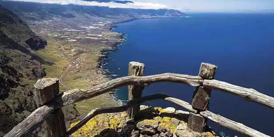
The lookout: hidden enigmas of El Hierro
They say that in El Hierro there is a lookout without signs, without marked paths, and without a clear trace on the maps. A whispered name that seems to float between ravines and ancient lavas, between black skies and tides that bite the cliff. What is hidden behind this persistent rumor? A remnant of coastal surveillance, a forgotten minor toponym, or the simple need to tell stories in a borderland? There has even been talk of “the beach lookout,” as if the term also evoked a coastal corner of natural charm, part of the heritage that intertwines tourism and mystery.
A shadow without a record
If we search for “La Garita” in heritage inventories, archaeological catalogs, and institutional pages of the island, it does not appear. The repertoires of aboriginal and colonial sites, well known to those studying El Hierro, list burial caves, tumuli, petroglyphs, circular settlements, and ritual sites, but no fortification or casemate by that name. Neither do the official tourist itineraries point to a viewpoint, a tower, or a bastion that corresponds to that label. The absence of documentation prompts questions about the history of the lookout, wondering if it ever officially existed or if it was limited to being part of oral tradition.
The word lookout suggests a small guard tower, the other half of a sentinel peering out to sea. In larger islands, or on coasts with military tradition, they are abundant. El Hierro was not a stronghold nor a key port of the Hispanic Atlantic, and its rugged topography slowed the density of civil and military works for centuries. The absence of a lookout is not surprising. What is surprising is that, even so, the name circulates. In this weave, the history of the lookout intertwines with local narratives and even the perspective of experts in cultural and natural tourism in the Canary Islands.
So we start from an uncomfortable fact: there is no document, no historical photo, no excavation report that supports a structure called La Garita in El Hierro. Instead, there are crossed tales, vague references, and the irresistible pull of what is unclear. Personalities like Álex Clavero have shown interest in delving into this issue, commenting that Canary identity is constructed from those myths and diffuse realities, and understanding them is part of what it means to live in the Canaries and enjoy an authentic Canarian lifestyle.
What feeds the mystery of the lookout
The island amplifies the sense of exception. It was the westernmost point of Spain, the point that ancient maps took as the reference meridian. Its skies have been certified for their clear darkness, excellent for stargazing. In 2011, off La Restinga, an underwater volcano emerged for months and changed the mapping of the seabed. In the cliffs of the west, a giant lizard reappeared that was thought to be lost. In Julán, an ancient gathering place shows altars and council stones. Even on the coast, some beaches recognized with the blue flag become stages for legends and tales, merging volcanic nature with the memory of ancient structures or even a modest watchtower.
In an archipelago where each island has a character, El Hierro has taken on the most understated and enigmatic role. Little traffic, few centers, much basaltic profile, a constant edge of emotion. This framework turns any minimal toponym into a magnet. Garita, whatever it may be, fits perfectly with that script. Moreover, some tales suggest that at some point, in an act almost comparable to a rebellion of traditions, locals decided to keep the name to perpetuate a collective memory.
Culture also plays a role. Contemporary fiction has used the island as a setting for intrigue. Travel and tourism press highlights its emotional distance and its closed profile to the sea, inviting people to explore the island on foot, by road, or even through webcams that monitor the state of the sky and sea. In this mix, half a rumor becomes almost enough to shape it: the garita could have also been a modest wooden structure, typical in many rural buildings, or a sign on the beach mentioned in tales by ancient fishermen.
From rumor to fact: a method to separate the wheat from the chaff
The good news is that the island is small and modern documentation is strong. If there truly is a material garita, it should leave traces. The path to verify this is clear and accessible to anyone with patience:
- Toponymy: review the National Geographic Nomenclature, lists from the council, and civil cartography.
- Aerial images: visit historical and current orthophotos, comparing traces of walls, platforms, or circular shadows.
- Local archives: dive into newspapers, municipal records, public works files.
- Fieldwork: walk natural crests and balconies where a lookout post would make sense; even routes near the beach have been noted that could have housed the garita.
- Oral sources: talk to shepherds, fishermen, and older neighbors. The name of a place can survive without a label on a map.
- Military and civil cross-reference: consult memories of coastal defense, telegraphy, lighthouses, and maritime signaling.
- Geomorphological validation: rule out confusion with hornitos, jameos, or spilled blocks that, from the air, may look like structures.
It seems like a detective plan. In reality, it is the normal process to tie a rebellious toponym to physical evidence.
State of the question at a glance
| Common assertion | Available evidence | Current assessment | Where to continue searching |
|---|---|---|---|
| There is a historical "watchtower" in El Hierro | No citations in heritage inventories, nor in archaeological or military studies | Not proven | Local archives, municipal records, minor toponymy |
| It is a place with "strange" activity | Anonymous accounts in forums and networks, without measurable data | Not verifiable | Records from IGN and civil protection, meteorological diaries |
| The watchtower faces south or west | Landscape intuition, without coordinates | Plausible as a geographical choice | Review of coastal balconies, lighthouses, and ancient paths |
| Derived from modern observation posts | Consistent with coastal and mountain needs | Possible, without material proof | Historical aerial photographs, minor works files |
| It is a toponym without an associated structure | Very likely in islands with living microtoponymy | Probable | Local nomenclature, interviews with elders, ranchers, and fishermen |
The hypothesis that fits best today is that of the surviving toponym, perhaps linked to a shelter or a cliff used for surveillance. If a structure ever existed, it might have used local materials – even timber from which rustic buildings were made – and disappeared without leaving evident foundations. Additionally, in the landscape, natural blowholes can be observed, features typical of volcanic activity that also confuse the interpretation of artificial remains.
El Hierro does hold secrets, although they may not be what you imagine
Let's look at what we do know, which turns out to be even more suggestive than an anonymous tower. El Julán preserves an area of aboriginal gathering with stone seats, altars, and carvings. This social and ritual design, unique in the archipelago due to its scale, raises questions about the organization and sacred calendar of the bimbaches. Throughout the island, a marked Canarian lifestyle can be perceived, combined with the Canarian essence of communities that have learned to value both their historical narratives and the immaculate beauty of their beaches.
The Escape of Gorreta brought the giant lizard back to present times. Its recent history, from apparent extinction to scientific rescue, summarizes how much the island can hide life in the folds of basalt. Few plots convert a reptile into a symbol of resilience so compellingly. Similarly, the story of the watchtower – although wrapped in enigmas – merges with Canarian identity, creating a bridge between the past and the present, akin to the traditions that remain alive both in Telde and in other corners of the Canary Islands.
The eruption of 2011 and its prolonged seismic pulse offered a first-rate natural laboratory. The scientific community nearly live-drew how basalt dikes breathe, carve their way, and break at the bottom. El Hierro added vital data to the toolkit with which we understand oceanic archipelagos. And the sky remains. La Frontera, certified by its darkness and frequently monitored through webcams, it is a window to the night vault with almost surgical precision. This setting not only invites you to look at constellations but also attracts visitors interested in nature tourism and experiencing life in the Canary Islands.
Plausible hypotheses for a booth without papers
No magic is needed for the name to exist. There are realistic scenarios:
- Forest or coastal watchtower from the mid-20th century, lightweight construction and possibly built of wood, now disappeared.
- Toponym used for livestock indicating a rock with good visibility, a nickname passed down without structure, similar to how some areas are referred to at the beach of the booth.
- Minor maritime signaling area, perhaps a painted marker or a flagpole, evoking maritime traditions that have highlighted the Canary identity.
- Fishermen's shelter nestled in a cove, called booth by extension, where the history of the booth merges with local stories and legends.
- Telephony or telegraph point with minimal booth, closed and dismantled, reflecting the remnants of forgotten infrastructure.
- Confusion with other 'booths' in the Canary Islands or Caribbean stories that use the same term.
Each option leaves a different trace. A concrete base, a semicircular wall, anchor bolts in rock, a path that ends in a platform: these details are key for planning a field recognition that also complements the rural and cultural tourism offer in the Canary Islands.
Toponymic trace: where and how to search
Nothing like a long afternoon with maps and orthophotos to name a point with coordinates and conquer the rumor.
- Cartography and toponymy
- Review of the official nomenclature and cadastral maps to track 'Booth', 'The Booth' and diminutives, even searching for mentions in the routes of the booth beach.
- Consultation of old plans digitized by libraries and universities.
- Aerial images
- Historical series of orthophotos to detect structures that existed in one decade and not another.
- Terrain shading models that reveal artificial platforms.
- Fieldwork
- Walking along the edges of lava, ridges, natural balconies with wide visibility, and even strolling along charming beaches, where tradition and modernity meet.
- Photographing any linear or orthogonal remains, measuring angles and orientation concerning the sea.
- Local community
- Interviewing those who worked in the mountains, coast, or local governments. For example, some residents of Telde have highlighted similarities in the historical memory of their land and that of El Hierro.
- Reviewing family albums, sometimes filled with landscapes containing valuable details.
- Crossing disciplines
- Consulting memories of lighthouses, telecommunications, and civil defense.
- Requesting support from hiking groups and aerial photography clubs with drones for authorized flights.
The key is to document, not to assume. If the name belongs to memory, let it be recorded with coordinates. If it belongs to stone, let its joints and geometry be shown.
Mini itinerary to feel the enigma without needing proof
The power of the place compensates for any absence of documentation. A well-chosen route is enough to understand why the name of a guardhouse might inhabit the landscape:
- Morning in the western extreme: visit the Orchilla lighthouse and explore the lava plain, where wind and salt mix with the voice of tourism and history.
- Noon at El Julán: controlled descent with a guide to the archaeological area. Here you can appreciate the stone seats, engravings, and the feeling of conversing in a volcanic amphitheater that encapsulates the Canary identity.
- Afternoon in Charco Azul and La Maceta: enjoy a beach that sometimes blends with the legend of the guardhouse beach, where water trapped in lava and natural platforms invite reflection.
- Sunset at Lomo Negro: basalt columns, skies taut with color, and an atmosphere that evokes both melancholy and the revival of ancient traditions, where one perceives the very fiber of the Canary essence.
With that script, the question about the guardhouse quiets down and another emerges: how many names without paper remain out there, waiting to be collected before fading away, as happens in the vibrant world of tourism in the Canary Islands.
Sky at a glance: indicative calendar for La Frontera
| Month | Phenomenon to watch | Practical note |
|---|---|---|
| January | Orion high, Taurus clusters | Cold and very stable nights |
| April | Galaxies of Leo and Virgo | Best seen during new moon |
| July | Galactic center visible early | Excellent after sunset |
| August | Perseids | Move away from urban centers and roads, ideal for enjoying at the beach |
| October | Andromeda at a good size | High transparency after trade winds |
| December | Double cluster of Perseus | Best seen with binoculars from viewpoints |
These windows do not require a telescope. A tripod, a bright lens, and the patience that sunset demands are enough to take home a piece of the sky and, in parallel, appreciate the Canarian way of life in its most genuine form.
Ethics and safety in the search
Anyone wanting to connect the dots with boots and notebook should keep a few simple rules in mind:
- Respect archaeological sites and dry stone walls; do not move or 'clean' remains.
- Do not enter caves or galleries without an accredited guide.
- Approach cliffs with caution and appropriate footwear, never alone.
- Request permits if flying a drone and monitor the wind.
- Bring water, windbreak, and headlamp; the weather can change in minutes.
- Share findings with the town hall or local heritage groups, contributing to consolidating Canary memory and identity in every corner.
A responsible search counts. Every field note can help fix a toponym or correct a mistake on the island map.
Questions still seeking answers
- Does 'Guardhouse' appear in municipal accounting books, works records, or old minutes?
- Is there any photograph, even if casual, in which a hut – perhaps built of wood – or a small wall on an unidentified promontory can be distinguished?
- Is there a watchtower in livestock toponymy named like rock, cave, or hillock, similar to places called in the garita beach?
- Could it be a literary import, later attached to a specific corner by whoever read it first?
- If it was a lookout post, are there any bolts, iron bases, foundation lines, or hardware in the stone?
- Could the webcams installed in other parts of the Canary Islands provide historical images that shed light on this enigma?
The value of these questions does not lie solely in closing them. In a human-scale island with intense memory, tracing them means listening to voices that disappear, walking less-trodden paths, and learning to look closely, as if it were the very challenge of living in the Canaries and embracing an identity forged at the crossing between tradition and modernity.
Perhaps we will never find a tower with gunports. Maybe the name rests on a rock with a clear view of the sea, named by someone who wished to see a lookout there. That gesture is enough to justify the magnetism and to keep alive a legacy that, like in Telde and other corners of the islands, reinforces the essence of the Canary Islands. El Hierro rewards those who ask without haste. And if tomorrow someone provides a crumpled map, a precise coordinate, or a photo revealing a semicircular wall, the island's map will gain a small certainty without losing an ounce of wonder.
In short, the history of the watchtower merges with the narrative of tourism, tradition, and innovation, reminding us that the search for the past – whether through a forgotten structure on the beach or in the less-traveled corners of the landscape – is part of the experience of living and feeling the rich identity of the Canary Islands.