
Las Islas Canarias, situadas en el océano Atlántico, son un archipiélago volcánico con una historia geológica de millones de años
GEOLOGICAL EVOLUTION OF THE CANARY ISLANDS
Their formation is related to a hotspot in the Earth's mantle, where magma rises and gives rise to new islands. This process is part of the geoevolution of the archipelago, which has gone through different phases over time.
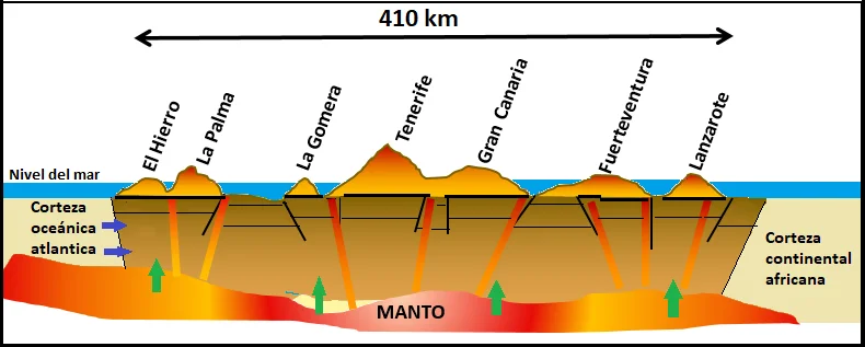
The geological evolution of the archipelago has developed in several phases:
Submarine Phase
More than 20 million years ago, magma began to emerge from the ocean floor, accumulating to form underwater mountains. Over time, these structures grew to reach the surface, giving rise to the first islands.
Geology of the Canary Islands – Emerging Phase
During this stage, the islands continued their growth through successive volcanic eruptions. Large volcanic structures were formed, such as Teide in Tenerife and Roque Nublo in Gran Canaria. This phase was marked by intense volcanism and tectonic movements, fundamental in the geoevolution of the archipelago.
Erosion and Stability Phase
Once the main volcanic activity ceased, erosion began to shape the landscape. Factors such as wind, rain, and wave action have sculpted ravines, cliffs, and valleys. In some islands, like Fuerteventura and Lanzarote, erosion has been more intense due to their greater age, evidencing a new stage in the geoevolution of the islands.
Geological formation of the Canary Islands – Recent Volcanic Activity
Despite the apparent stability, the Canaries remain a volcanically active territory. Recent eruptions, such as that of the Tajogaite volcano in La Palma in 2021, demonstrate that the geological process continues, maintaining the geoevolution of the archipelago in motion.
In conclusion, the formation of the Canary Islands is the result of millions of years of volcanic activity and erosion. This process is ongoing, shaping the landscape and biodiversity of the archipelago, within a constant dynamic of geoevolution.
The geology of the Canary Islands live
The phases we have described are visible in the landscape of the islands, and some of our live webcams allow us to observe them in real time:
- Teide National Park: the great stratovolcano of Tenerife and the surrounding Cañadas.
- Live seismic activity of Tenerife: the Teide seismograph in real time.
- Cliffs of Los Gigantes: walls of volcanic rock shaped by erosion from the sea.
- Roque de los Muchachos: the summit of La Palma, next to the Caldera de Taburiente.
- La Restinga: off its coast, the submarine eruption of El Hierro occurred in 2011.
- View from Montaña Mina: the volcanic landscape of central Lanzarote.